Motivation
President Joko Widodo expressed the desire to relocate Indonesia’s capital city to alleviate some of the problems that Indonesia is facing such as :
- Jakarta being overpopulated
- All major businesses, infrastructure and central government functions being concentrated at Jakarta. This would lead to any places outside of Jakarta to have a small chance to grow economically
- Jakarta is environmentally challenged. Traffic congestion are so bad that it is the main contributor of air pollution in the city
- Clean water supply is running low in Jakarta
- Rising sea levels are casuing the usable land area of Jakarta to shrink at a concerning rate
- Jakarta is in close proximity to volcanoes and major fault line
Project objective
As part of the plan, part of Kutai Kartanegara Regency (Kabupaten Kutai Kartanegara) and Penajam North Paser Regency (Kabupaten Penajam Utara) in East Kalimantan will be carved out to create a new province-level planned city, and the capital will be relocated to a more central location within Indonesia. The plan is part of a strategy to reduce developmental inequality between Java and other islands in the Indonesian archipelago and to reduce Jakarta’s burden as Indonesia’s primary hub. President Joko Widodo, known as Jokowi, said the relocation will help spread economic activities outside of the most-populous island of Java and narrow its income gap with the rest of the country.
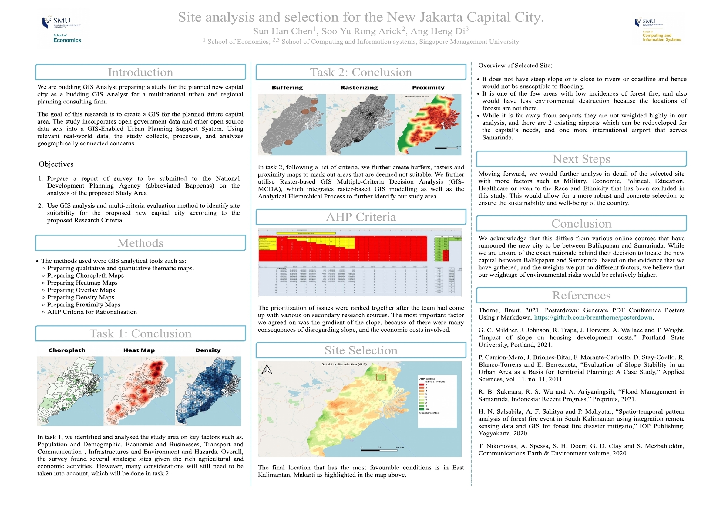
Task 1 : Report of Survey Indonesia New National Capital Development Plan
Prepare a report of survey to be submitted to the National Development Planning Agency (abbreviated Bappenas) with the following themes :
- Population and Demographic
- Economic and Businesses
- Transport and Communication
- Infrastructure
- Environment and Hazard
Task 2
Use GIS analysis and multi-criteria evaluation method to identify site suitability for the proposed new capital city by using the criteria below:
- It should be between 4500-5500 hectares in size
- It should avoid steep slope. Steep slope developments are relative more costly because they involve cut-and-fill and is less environmental friendly.
- It should be away from potential natural disaster risk areas such as sea coasts, major rivers and volcanoes.
- It should be near to current urban settlement areas but not at the current major settlement areas.
- It should avoid natural forest as much as possible.
- It should avoid areas prone to forest fire.
- It should be highly accessible via road transport.
- It should be near to airport(s) and seaport(s).
Data
Given datasets :
For the purpose of this project, the following data sources are recommended but students are welcome to include other appropriate data.
- Batas Desa & Data Kependudukan Tahun 2019 Seluruh Indonesia. This data set provides comprehensive population data at the sub-district level. In Indonesia local language, they are known as kota (i.e. urban sub-district) and desa (i.e. rural sub-district). You are required to download data set for Provinsi Kalimantan Timur (i.e. East Kalimantan Province).
- Rupa Bumi Iindonesia (RBI) Provinsi Kalimantan Timur Perwilayah (Kabupaten/Kota). The term rupabumi means topographic. This data repository provides a coprehensive collection of topographical data layers of East Kalimantan. You are required to download data of Kota Balikpapan, Kota Samarinda, Penajam Paser Utara and Kutai Kartanegara.
- DEM SRTM 30m, digital elevation model at 30m resolution.
- Geological data layer.
- Forest fire hot spot data. This repository provides several years of forest hot spots data.
- Buildings and Settlements.
Additional datasets :
Scope of work
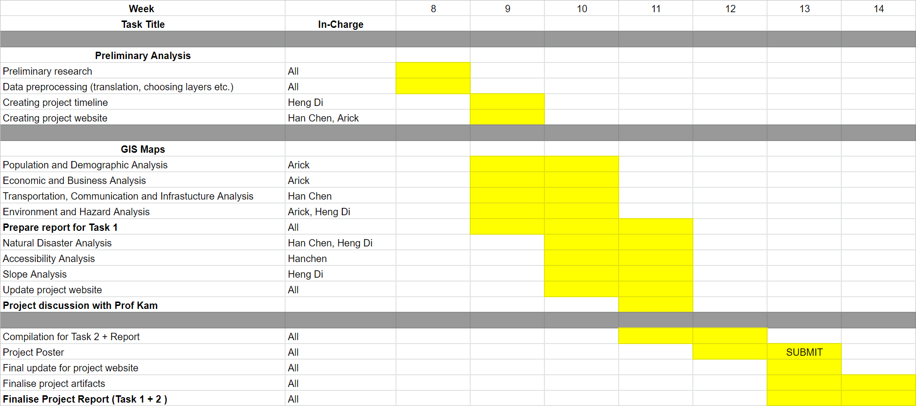
The project will comprise of, but not limited to the followings steps:
- Selection of project area, this year the project area is provided.
- Data collection, extraction, integration, transformation and wrangling.
- Designing and building GIS model and database
- Preparing report of survey
- Performing site suitability analysis by integrating GIS and multi-criteria evaluation methods.
- Preparing site suitability analysis report including detail discussion of the analysing method used.
- Preparing poster and project webpage.
Project schedule (Gantt chart)
Project Poster