
Site analysis and selection for the New Jakarta Capital City.
Sun Han Chen1, Soo Yu Rong Arick2, Ang Heng Di3
1 School of Economics; 2,3 School of Computing and Information systems, Singapore Management University

Introduction
We are budding GIS Analyst preparing a study for the planned new capital city as a budding GIS Analyst for a multinational urban and regional planning consulting firm.
The goal of this research is to create a GIS for the planned future capital area. The study incorporates open government data and other open source data sets into a GIS-Enabled Urban Planning Support System. Using relevant real-world data, the study collects, processes, and analyzes geographically connected concerns.
Objectives
Prepare a report of survey to be submitted to the National Development Planning Agency (abbreviated Bappenas) on the analysis of the proposed Study Area
Use GIS analysis and multi-criteria evaluation method to identify site suitability for the proposed new capital city according to the proposed Research Criteria.
Methods
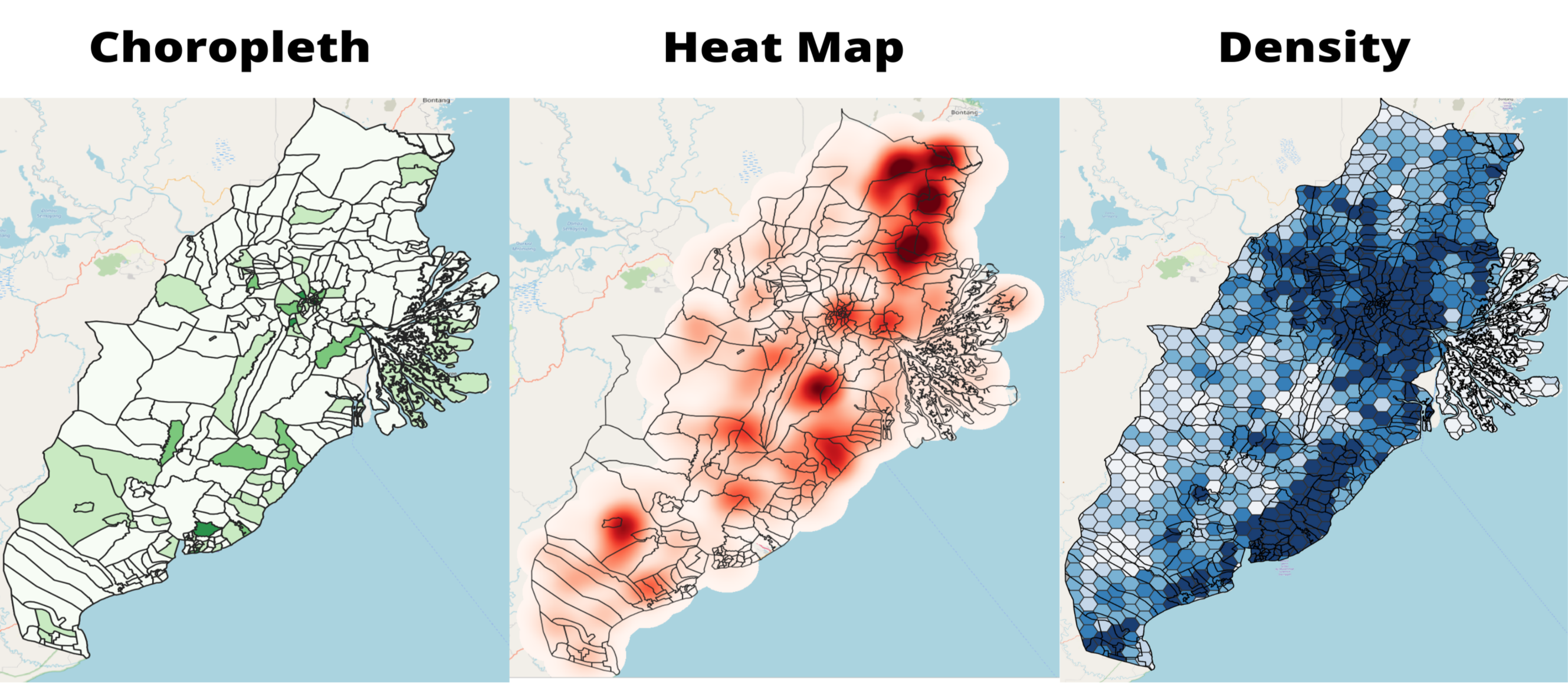
- The methods used were GIS analytical tools such as:
- Preparing qualitative and quantitative thematic maps.
- Preparing Choropleth Maps
- Preparing Heatmap Maps
- Preparing Overlay Maps
- Preparing Density Maps
- Preparing Proximity Maps
- AHP Criteria for Rationalisation
Task 1: Conclusion
In task 1, we identified and analysed the study area on key factors such as, Population and Demographic, Economic and Businesses, Transport and Communication , Infrastructures and Environment and Hazards. Overall, the survey found several strategic sites given the rich agricultural and economic activities. However, many considerations will still need to be taken into account, which will be done in task 2.
Task 2: Conclusion
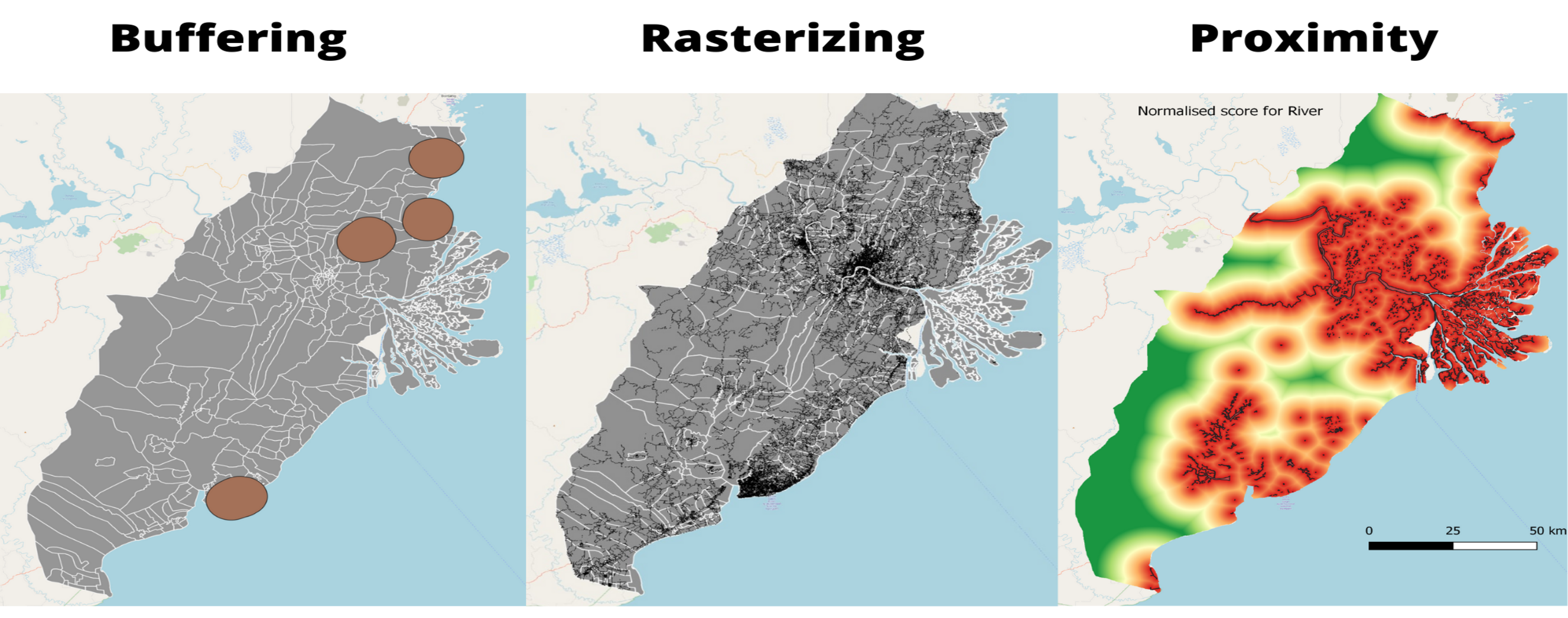
In task 2, following a list of criteria, we further create buffers, rasters and proximity maps to mark out areas that are deemed not suitable. We further utilise Raster-based GIS Multiple‐Criteria Decision Analysis (GIS-MCDA), which integrates raster-based GIS modelling as well as the Analytical Hierarchical Process to further identify our study area.
AHP Criteria
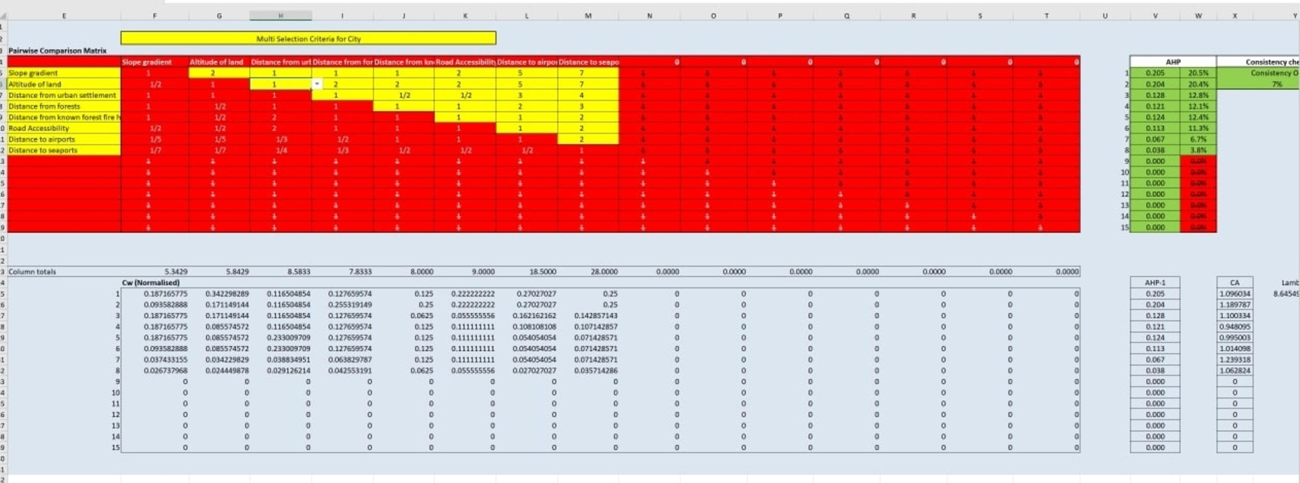
The prioritization of issues were ranked together after the team had come up with various on secondary research sources. The most important factor we agreed on was the gradient of the slope, because of there were many consequences of disregarding slope, and the economic costs involved.
Site Selection
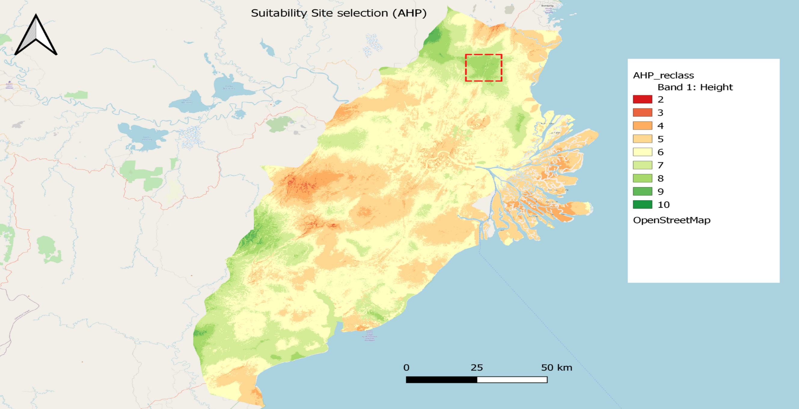
The final location that has the most favourable conditions is in East Kalimantan, Makarti as highlighted in the map above.
Overview of Selected Site:
- It does not have steep slope or is close to rivers or coastline and hence would not be susceptible to flooding.
- It is one of the few areas with low incidences of forest fire, and also would have less environmental destruction because the locations of forests are not there.
- While it is far away from seaports they are not weighted highly in our analysis, and there are 2 existing airports which can be redeveloped for the capital’s needs, and one more international airport that serves Samarinda.
Next Steps
Moving forward, we would further analyse in detail of the selected site with more factors such as Military, Economic, Political, Education, Healthcare or even to the Race and Ethnicity that has been excluded in this study. This would allow for a more robust and concrete selection to ensure the sustainability and well-being of the country.
Conclusion
We acknowledge that this differs from various online sources that have rumoured the new city to be between Balikpapan and Samarinda. While we are unsure of the exact rationale behind their decision to locate the new capital between Balikpapan and Samarinda, based on the evidence that we have gathered, and the weights we put on different factors, we believe that our weightage of environmental risks would be relatively higher.
References
Thorne, Brent. 2021. Posterdown: Generate PDF Conference Posters Using r Markdown. https://github.com/brentthorne/posterdown.
G. C. Mildner, J. Johnson, R. Trapa, J. Horwitz, A. Wallace and T. Wright, “Impact of slope on housing development costs,” Portland State University, Portland, 2021.
P. Carrion-Mero, J. Briones-Bitar, F. Morante-Carballo, D. Stay-Coello, R. Blanco-Torrens and E. Berrezueta, “Evaluation of Slope Stability in an Urban Area as a Basis for Territorial Planning: A Case Study,” Applied Sciences, vol. 11, no. 11, 2011.
R. B. Sukmara, R. S. Wu and A. Ariyaningsih, “Flood Management in Samarinda, Indonesia: Recent Progress,” Preprints, 2021.
H. N. Salsabila, A. F. Sahitya and P. Mahyatar, “Spatio-temporal pattern analysis of forest fire event in South Kalimantan using integration remote sensing data and GIS for forest fire disaster mitigatio,” IOP Publishing, Yogyakarta, 2020.
T. Nikonovas, A. Spessa, S. H. Doerr, G. D. Clay and S. Mezbahuddin, Communications Earth & Environment volume, 2020.